Define the environment
Identify the civilian application, capture area and operating conditions.
Air–ground mapping · Visual positioning
AG-RMS brings vehicle and drone mapping into one synchronized field view. ZhiTu VisNav explores map-referenced visual navigation, with a reported 740-frame campus trial and a clear embedded-engineering roadmap.
Illustrative schematic. Not actual field data or a navigation display.
From the technical profile
Specific capabilities. Reported measurements. Follow each figure to its source context and application.
AG-RMS mapping system
<200 msProfile-reported synchronization of air and ground information on the shared display.
Technical details ↗AG-RMS mapping system
≤2 cmSource label: absolute positioning accuracy. Elevation is listed separately at ≤3 cm.
Technical details ↗ZhiTu VisNav
9.8 mReported at 120 m altitude in the campus trial; this is a median, not a maximum-error bound.
Technical details ↗ZhiTu VisNav
740Profile-reported closed-loop sequence; not 740 independent flights.
Technical details ↗Systems
Explore the technology, source-reported performance, reference configurations and application scenarios.
AG-RMS combines vehicle and drone capture on a customized QGroundControl display. The profile reports <200 ms synchronization, absolute positioning accuracy ≤2 cm, elevation ≤3 cm and operation over an encrypted in-vehicle LAN.
Map-referenced visual navigation using a down-facing camera and edge compute. A reported 740-frame campus trial achieved a median position deviation of 9.8 m at 120 m altitude, with an unoptimized prototype time of 0.23 s/frame.
Explore how it works
Principle & workflow

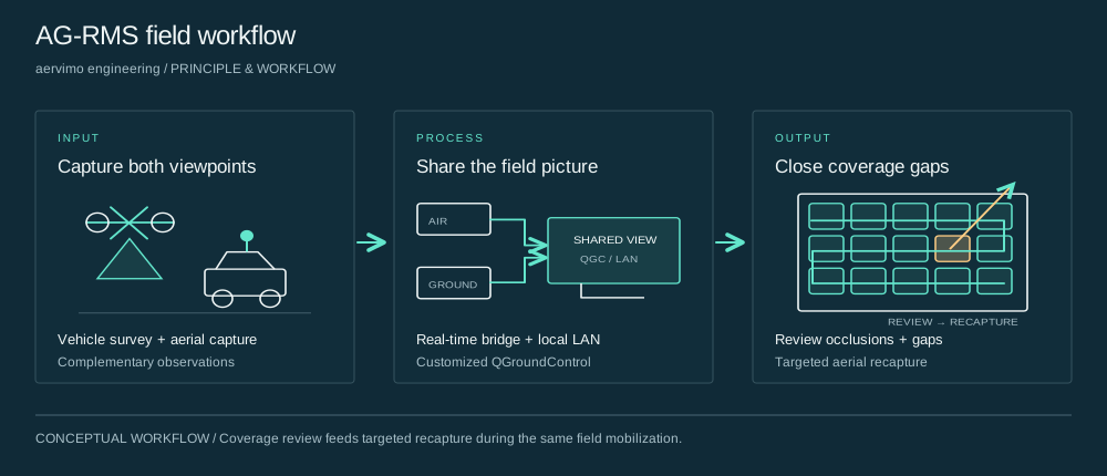
Ground and aerial capture provide complementary viewpoints of the survey area. The goal is to observe surfaces that one platform alone may miss.
A proprietary data bridge and multi-vehicle communications middleware bring positions, attitudes and trajectories onto the vehicle display over the described encrypted local network.
Operators examine the common coverage view and identify missing observations while still on site. Aerial recapture can then address the selected gaps before demobilization.
The way we work
Identify the civilian application, capture area and operating conditions.
Check sensors, reference maps, data access and integration boundaries.
Measure coverage or positioning against agreed reference data.
Document failure cases, support needs and the next engineering milestone.
Technical notes
The next step