Median position deviation
Reported at 120 m altitude in the campus trial; this is a median, not a maximum-error bound.
POSITIONING RESEARCH Campus-tested prototype · Engineering migration
Map-referenced visual navigation using a down-facing camera and edge compute. A reported 740-frame campus trial achieved a median position deviation of 9.8 m at 120 m altitude, with an unoptimized prototype time of 0.23 s/frame.
Discuss a civilian OEM evaluation ↗Technical highlights
Reported capabilities and figures from the supplied technical profile, with their application context.
Reported at 120 m altitude in the campus trial; this is a median, not a maximum-error bound.
Profile-reported closed-loop sequence; not 740 independent flights.
Unoptimized prototype measurement; not a released embedded-platform latency specification.
Campus environment used for the reported evaluation.
Source: Technical Capabilities — External Presentation · 2026-08 · pp. 13. Source and scope ↓
Engineering overview
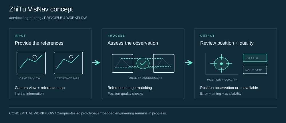
ZhiTu VisNav compares onboard camera imagery with a preloaded satellite or aerial reference map to produce an absolute visual position observation. The concept combines inertial information, learned reference-image matching and a quality gate. The profile describes a real campus trial and ongoing migration to an embedded platform.
Principle & workflow

The prototype concept uses a down-facing camera, a preloaded satellite or aerial map and inertial information. Map and image conditions define the evaluation context.
At a system level, reference-image matching produces a candidate observation and quality checks assess its usability. The result can be reported as usable or unavailable depending on the observation quality.
Evaluate the output against independent reference information, including position error, timing, false matches and intervals without a usable observation. Embedded engineering remains in progress.
System concept
A down-facing camera and edge-computing board use a preloaded satellite or aerial map as a reference for absolute visual positioning.
System concept
The public architecture combines inertial information, reference-image matching and quality checks to assess whether a visual position observation is usable.
Trial evidence
The profile reports rejecting confident but incorrect position matches. Evaluation therefore includes false matches and availability alongside typical position error.
| Measure | Reported value | Context |
|---|---|---|
| Reported reacquisition after map exit | 100% | Observed in the described sequence, with no loss or divergence reported; the number of reacquisition events is not given. |
| Largest cited false-position error | 430 m | The quality gate reportedly rejected high-confidence false matches up to this deviation. |
| Reported false-match rejection | 100% | Reported for the described test; the number of false-match events and broader operating-domain statistics are not provided. |
| Item | Condition / observation |
|---|---|
| Environment | Real campus scene with approximately 1300 × 1300 m reference map |
| Altitude | 120 m for the cited median-error result |
| Sequence | 740 consecutive localization frames |
| Position deviation | 9.8 m median |
| Prototype timing | 0.23 s/frame, unoptimized |
| GPS use | First-frame initialization; the profile states GPS was not used for subsequent position estimates |
| Reference comparison | The profile shows GPS ground truth compared with visual estimates |
| Reacquisition and false matches | 100% figures are sequence-specific; event counts are not disclosed |
| Stage | Status described in the profile |
|---|---|
| Campus validation | Completed prototype sequence reported |
| Rockchip RK3588 migration | In progress |
| NPU quantization and C++ pipeline engineering | In progress |
| Real-time platform interface integration | In progress |
Applications & value
Application context
Evaluate a map-referenced position observation in controlled conditions when conventional positioning is unavailable or unreliable.
Application context
Review map dependence, camera conditions, latency, typical error and incorrect matches before defining an integration program.
Application context
Compare the intended operating environment with the reported campus scene and identify the additional evidence needed.
Who it's for
Civilian OEM navigation and autonomy teams with controlled engineering evaluation capabilities.
Bring the application, representative inputs and acceptance criteria. We will connect the relevant technology and platform to a defined engineering deliverable.
Before we begin
The supplied profile reports 740 consecutive localization frames over a roughly 1300 × 1300 m campus reference area, 9.8 m median position deviation at 120 m altitude and 0.23 s/frame for the unoptimized prototype.
The profile states that GPS was used for the first frame and not for subsequent position estimates. It separately shows GPS ground truth for comparison with visual estimates.
They refer to reacquisition after leaving the map and rejection of false matches in the described sequence. Event counts and wider operating-domain statistics are not supplied, so the figures are not universal guarantees.
The profile describes migration to Rockchip RK3588, NPU quantization, C++ engineering and interface integration as ongoing. The offering is a prototype evaluation rather than a claimed released production SDK.
The next step