Synchronization delay
Profile-reported synchronization of air and ground information on the shared display.
MAPPING COORDINATION Integrated system · Field pilot scoping
AG-RMS combines vehicle and drone capture on a customized QGroundControl display. The profile reports <200 ms synchronization, absolute positioning accuracy ≤2 cm, elevation ≤3 cm and operation over an encrypted in-vehicle LAN.
Plan a mapping pilot ↗Technical highlights
Reported capabilities and figures from the supplied technical profile, with their application context.
Profile-reported synchronization of air and ground information on the shared display.
Source label: absolute positioning accuracy. Elevation is listed separately at ≤3 cm.
Reported point-cloud density for the described AG-RMS configuration.
Reported linear survey work rate; actual route and capture conditions are not specified.
Source: Technical Capabilities — External Presentation · 2026-08 · pp. 12. Source and scope ↓
Engineering overview
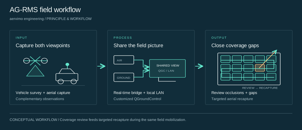
AG-RMS brings ground-vehicle and aerial viewpoints into one mapping workflow. A proprietary real-time data bridge and multi-vehicle communications middleware synchronize positions, attitudes and trajectories on the vehicle’s QGroundControl display. Operators review occluded areas and coverage gaps while still on site, then assign targeted aerial recapture.
Principle & workflow

Ground and aerial capture provide complementary viewpoints of the survey area. The goal is to observe surfaces that one platform alone may miss.
A proprietary data bridge and multi-vehicle communications middleware bring positions, attitudes and trajectories onto the vehicle display over the described encrypted local network.
Operators examine the common coverage view and identify missing observations while still on site. Aerial recapture can then address the selected gaps before demobilization.
Synchronized field workflow
Display vehicle trajectories and drone positions and attitudes together, giving the operator a view of captured areas and places needing another viewpoint.
Coverage review
Use aerial capture to complement ground-level blind areas. The intended value is to discover and fill omissions during the same mobilization.
Offline operation
The described configuration transfers data through an encrypted in-vehicle LAN and does not require an internet connection for that workflow.
| Measure | Reported value | Context |
|---|---|---|
| Elevation accuracy | ≤3 cm | Separate source-listed elevation figure; validate against independent survey control. |
| Single-pass coverage claim | 100% | Source-stated workflow claim. Required surfaces and trial denominator are not defined, so this is not a universal coverage guarantee. |
| Comparison with traditional surveying | 10× | Reported comparison figure; the baseline and calculation method are not provided. |
| Shorter project duration | 80% | Separately reported duration reduction. Do not treat this and the 10× figure as mathematically equivalent. |
| Component | Model / platform | Source-listed role or rating |
|---|---|---|
| LiDAR | RIEGL VUX-1HA-22 | 1.8 million points/s |
| Position and orientation | Trimble AP+60 Land | Positioning and attitude reference |
| Panoramic imaging | FLIR Ladybug 5+ | 30 megapixels |
| Aerial platform | DJI M350 RTK | Aerial capture platform |
| Common display | Customized QGroundControl | Air–ground positions, attitudes and trajectories |
| Data and communications | Proprietary real-time bridge + multi-vehicle middleware | Synchronized field workflow over an encrypted in-vehicle LAN |
This is the configuration identified in the supplied profile, not a claim of universal sensor compatibility.
Applications & value
Application context
Combine ground and aerial viewpoints for urban 3D reconstruction, reviewing occluded surfaces before the crew leaves.
Application context
Capture road corridors and surrounding assets with a common coverage view, then target areas missed by the vehicle.
Application context
Coordinate complementary observations of corridor assets and surrounding ground features for inspection and mapping.
Application context
Support civilian mapping and coverage review when public internet connectivity is unavailable.
Who it's for
Survey operators, geospatial teams and integration partners working on civilian infrastructure and industrial sites.
Bring the application, representative inputs and acceptance criteria. We will connect the relevant technology and platform to a defined engineering deliverable.
Before we begin
AG-RMS is an air–ground real-time mapping system built on customized QGroundControl, integrating vehicle and drone information with a proprietary real-time data bridge and multi-vehicle communications middleware.
It reports <200 ms synchronization, absolute positioning accuracy ≤2 cm, elevation ≤3 cm, point-cloud density >2000 points/m² and air–ground work rate >20 km/day. Full measurement conditions are not provided.
The described field workflow runs over an encrypted in-vehicle LAN without internet access. Network and hardware compatibility are defined for the project configuration.
The profile states 100% single-pass coverage, a 10× comparison figure and 80% shorter duration. It does not define the coverage denominator or comparative baseline; these are separate reported claims to evaluate in a scoped field trial.
The next step